Bridging the evidence gap in spatial planning
Lessons from assessing the impact of transport infrastructure
DOI:
https://doi.org/10.18335/region.v10i3.474Abstract
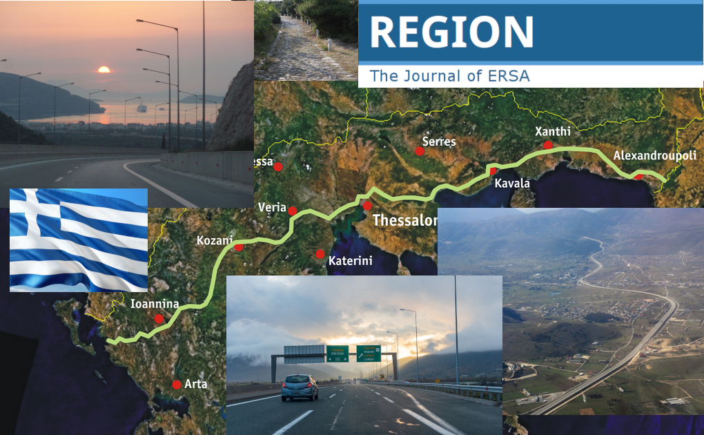
The article focuses on how the use of evidence in spatial planning could bridge the gap between vision and reality through the continuous evaluation of the spatial impacts of the proposed interventions. The introduction sets the theoretical, institutional, and practical context on how evidence is used to assess these impacts in relation to both the expected outcomes and the pursued policy priorities. The research section addresses these issues based on the empirical and methodological background derived from a series of successive studies carried out between 1999 and 2014. These studies are related to the establishment and operation of the spatial impact observatory of the Egnatia motorway, a major European transport infrastructure project in northern Greece. The results section introduces a methodological approach, succinctly referred to as the IRIS model in which spatial planning is conceived as an adaptive process, and the use of evidence aims to enhance its flexibility and preparedness in dealing with the uncertainties that arise from dynamic conditions, rather than relying solely on predetermined solutions. It comprises three key components: a theoretical model that simulates the relationship between transport infrastructure and spatial development, an intermediate data model in which raw data were constructed as evidence indicators, and a combination of inductive and deductive paths in which evidence is used to assess the anticipated impact of spatial plans and to evaluate the actual spatial outcomes after their implementation. Finally, the conclusions underline the value added of the IRIS approach as a comprehensive and integrative methodology that aims to improve the efficacy of spatial planning by establishing a link between theoretical models, policy objectives, and evidence-based decision-making.
Downloads
Published
How to Cite
Issue
Section


License
Copyright (c) 2023 Grigoris Kafkalas, Magda Pitsiava

This work is licensed under a Creative Commons Attribution 4.0 International License.
REGION is an open journal, and uses the standard Creative Commons license: Copyright We want authors to retain the maximum control over their work consistent with the first goal. For this reason, authors who publish in REGION will release their articles under the Creative Commons Attribution license. This license allows anyone to copy and distribute the article provided that appropriate attribution is given to REGION and the authors. For details of the rights authors grant users of their work, see the "human-readable summary" of the license, with a link to the full license. (Note that "you" refers to a user, not an author, in the summary.) Upon submission, the authors agree that the following three items are true: 1) The manuscript named above: a) represents valid work and neither it nor any other that I have written with substantially similar content has been published before in any form except as a preprint, b) is not concurrently submitted to another publication, and c) does not infringe anyone’s copyright. The Author(s) holds ERSA, WU, REGION, and the Editors of REGION harmless against all copyright claims. d) I have, or a coauthor has, had sufficient access to the data to verify the manuscript’s scientific integrity. 2) If asked, I will provide or fully cooperate in providing the data on which the manuscript is based so the editors or their assignees can examine it (where possible) 3) For papers with more than one author, I as the submitter have the permission of the coauthors to submit this work, and all authors agree that the corresponding author will be the main correspondent with the editorial office, and review the edited manuscript and proof. If there is only one author, I will be the corresponding author and agree to handle these responsibilities.
