Development of a Quantitative Model in Land Use Planning Using GIS
A Case Study of Zarrin Dasht County, Iran
DOI:
https://doi.org/10.18335/region.v9i2.448Abstract
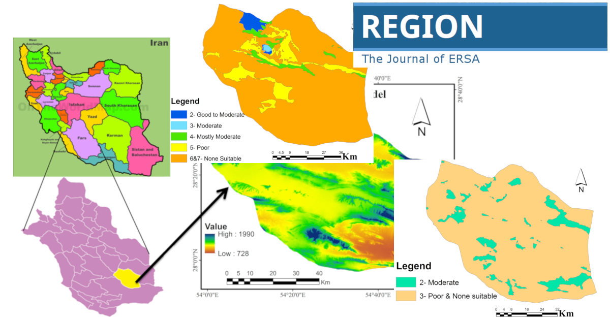
Land evaluation methods are crucial for evaluating the potentials and constraints of land for intended land use. In the procedure, environmental criteria such as topography, soil, climate, hydrology, and socioeconomic parameters are evaluated. Different technical procedures are also used for land evaluation ranging from simple methods based on expert knowledge to more complex methods based on simulation models. The main goal of this research is to evaluate land use and natural resources for future sustainable land planning using Geographic Information System (GIS). So, in this study, the Iranian ecological evaluation model was used for the analysis of the ecological and resources maps of the study area. First, ecological capability maps of different land uses such as forestry, agriculture, range management, environmental conservation, ecotourism, and development of villages, urban and industrial areas were developed by overlaying geographical maps based on Boolean overlay method (as a Multi-Criteria Evaluation Method) in GIS for the Township. The final step of this research was the prioritization of land uses considering the ecological and socio-economic characteristics (by distributing questionnaires to 63 experts (of the study area using a quantitative model. The results showed that the maximum area of proposed uses is 78.31\%, which is related to rainfed agriculture, showing this land use has high potential and socio-economic demands in the study area. Meanwhile, minimum area of proposed uses is related to forest and ecotourism. One of the most important practical results of this study is that different or even modified methods should always be used in the same region to check the capability of land and the common method will not always be as best method.
Downloads
Published
How to Cite
Issue
Section


License
Copyright (c) 2023 Masoud Masoudi, Parviz Jokar

This work is licensed under a Creative Commons Attribution 4.0 International License.
REGION is an open journal, and uses the standard Creative Commons license: Copyright We want authors to retain the maximum control over their work consistent with the first goal. For this reason, authors who publish in REGION will release their articles under the Creative Commons Attribution license. This license allows anyone to copy and distribute the article provided that appropriate attribution is given to REGION and the authors. For details of the rights authors grant users of their work, see the "human-readable summary" of the license, with a link to the full license. (Note that "you" refers to a user, not an author, in the summary.) Upon submission, the authors agree that the following three items are true: 1) The manuscript named above: a) represents valid work and neither it nor any other that I have written with substantially similar content has been published before in any form except as a preprint, b) is not concurrently submitted to another publication, and c) does not infringe anyone’s copyright. The Author(s) holds ERSA, WU, REGION, and the Editors of REGION harmless against all copyright claims. d) I have, or a coauthor has, had sufficient access to the data to verify the manuscript’s scientific integrity. 2) If asked, I will provide or fully cooperate in providing the data on which the manuscript is based so the editors or their assignees can examine it (where possible) 3) For papers with more than one author, I as the submitter have the permission of the coauthors to submit this work, and all authors agree that the corresponding author will be the main correspondent with the editorial office, and review the edited manuscript and proof. If there is only one author, I will be the corresponding author and agree to handle these responsibilities.
